…
Setting the Stage: Macomb's Purchase
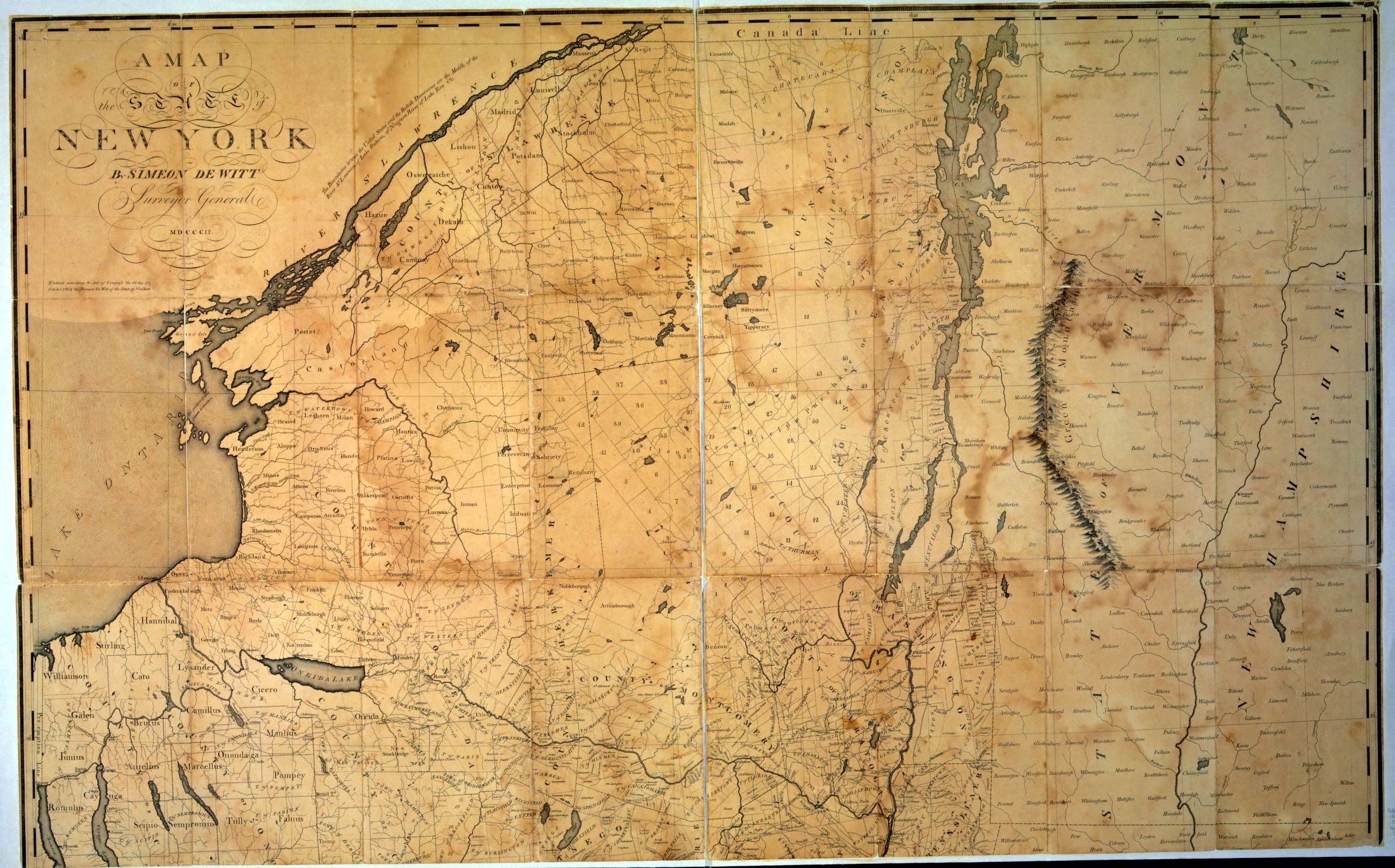
In 1784, the Oneida Indians ceded all of Northern New York to New York State. The land was mostly unsettled wilderness. Although the area served as a hunting ground for several Native American tribes, including the Oneida, their presence was minimal by this period.
A few ruined forts along the Saint Lawrence River were the only real trace of earlier Euro-American activity. The nearest American settlements were dozens of miles away, in the Mohawk Valley and along Lake Champlain.
Almost a decade later, in 1791, the New York State Board of Land Commissioners auctioned off most of the region - 3.7 million acres - in six “Great Tracts.” A New York City-based syndicate purchased all six of the Great Tracts at eight cents per acre. The leader of that syndicate was an Irish-born fur trader named Alexander Macomb.
Macomb’s Purchase included almost all of four present-day counties: Jefferson, Lewis, Saint Lawrence, and Franklin. The largest piece of land in the area excluded from the purchase, the Saint Lawrence Ten Towns, had been purchased by Macomb several years earlier.
Macomb may have made one of the largest private land purchases in the young history of the country, but he was not a developer: Instead, he hoped to make a fortune in land speculation. Macomb planned to divide his purchase into much smaller plots to be sold at a significant markup.
However, this plan never came to fruition. Macomb failed to swiftly capitalize on his purchase in Northern New York, and other unsuccessful business ventures quickly depleted his fortune. These failures drove Macomb into bankruptcy and debtor’s prison.
Macomb’s financial ruin left his associate, William Constable, with sole title to the southern portion of Macomb’s Purchase. Constable had been supervisor of Great Tracs Four, Five, and Six, which comprise most of present-day Jefferson and Lewis counties.
Attempting to find some way to profit off of his lands, Constable went to Paris with an offer for his friend, a French nobleman named James Le Ray de Chaumont: If Le Ray could find interested investors, Northern New York would become into a haven for refugees of the French Revolution.
…
Introducing James Le Ray de Chaumont
James Le Ray de Chaumont was the scion of a prominent family of French aristocrats. His father, Jacques Leray de Chaumont, had become wealthy as the owner of a merchant fleet, and he had earned his family’s aristocratic title several decades earlier with the purchase of the Chateau de Chaumont in the Loire Valley.
As someone who had made much of his fortune through sea trade, Jacques Leray had longstanding ties with the United States, and he ranked among the earliest and most fervent French supporters of the American Revolution. When Benjamin Franklin and John Adams came to France to plead for aid, Jacques Leray was their host, and he used his influence to buy Franklin and Adams time before the court of Louis XVI.
Jacques Leray loaned much of his family’s wealth to the American colonies during their revolution. After the war, the United States was unable to repay its debts, leaving Leray and his family on the brink of financial ruin. Leray also incurred losses through land speculation in North America, and the war disrupted sea trade, his primary source of income.
In 1785, Leray sent his twenty-five year-old son James to represent Jacques’ claims against the new American government. James spent several years pleading his father’s case before Congress, but met no success. (Le Ray may have been so young that Congress did not take him seriously.)
By 1789, Jacques Le Ray was bankrupt, and his creditors had begun to seize his family’s assets. James Le Ray gave up on the U.S. Congress and returned to France in the following year.
During his time in the United States, James Le Ray became an American citizen and married the daughter of a wealthy New Jersey family. This was also when he met and befriended a New York City-based fur trader named William Constable.
Years later, when Constable was trying to find something to do with a few hundred thousand acres of unsettled frontier wilderness in Upstate New York, he remembered James Le Ray’s aristocratic connections, financial desperation, and family ties to the United States. This was an obvious opportunity to make his lands profitable. The proposition caught Le Ray’s interest immediately.
…
Early Settlement: 1794 - 1805
James Le Ray’s intent was different from Macomb’s from the start: Le Ray was a developer, and his interest in the North Country was based a vision for what the land could become over decades rather than a short-term concern for profit. (Of course, recovering his family fortune was among Le Ray’s goals.)
In 1792, Le Ray partnered with his brother-in-law, Peter Chassanis, to form the Antwerp Land Company. Le Ray lacked the financial capacity to back this venture himself, but he made up for his lack of funds with connections and charm. With support from dozens of American and European investors, the Antwerp Land Company purchased over 600,000 acres, including all of Great Tract Four and portions of Great Tract Five lying north of the Black River.
Despite the skill with which Le Ray had attracted financial backing, the Antwerp Land Company’s purchase fell through within a year, and Le Ray was forced to return the land to Constable
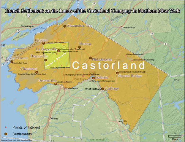
Two years later, in 1794, Le Ray and Chassanis attempted again to purchase land from Constable, this time with more success. The two Frenchmen formed the Castorland Company. The Castorland took its name from the French word for beaver, of which there were many in the region. (Castor oil is actually a vegetable oil, but it gets its name from its use as a replacement for castoreum, which is a tincture extracted from a beaver’s perineal glands.) The Castorland Company re-purchased 215,000 acres of the land that had the Antwerp Company had briefly held.
Peter Chassanis and Le Ray had already begun to make elaborate plans for Castorland - plotting locations of highways, bridges, mills, and even future cities - but it was Chassanis alone who led the first attempt at settlement by bringing twenty aristocratic families from France into the Black River Valley of present-day Jefferson and Lewis counties.
Chassanis’ group succeeded in building the first highway into the region, connecting the virtually uninhabited Black River Valley with the settlements of the Mohawk Valley. But the harsh environment and isolation proved too much for Chassanis’ party of high-born settlers to overcome. Fewer than expected had signed up for the expedition to begin with, and their first winter in Northern New York was much harsher than anyone had expected. Many of the French settlers died before the snows had melted, and most of those who remained left during the following spring.
Two villages stand today on the sites of the Chassanis company’s settlements: Carthage, originally named Long Falls, and Castorland. But no one living there now can trace their ancestry to Chassanis’ company: By 1814, every member of the original group of French settlers had either died or emigrated. Northern New York was not destined to become a bucolic haven for aristocratic refugees of the French Revolution.
Rather than ending Le Ray’s interest in Northern New York, this failure inspired him to adapt to the realities of the frontier environment. In 1798, when the New York State legislature prohibited non-citizens from owning property, Le Ray bought out his French partners to become the sole owner of Castorland. Furthermore, Le Ray set about purchasing the remaining lands that had once been purchased by the ill-fated Antwerp Company, and by 1800, Le Ray had re-acquired almost all of the original 600,000 acres.
In 1800, Le Ray sponsored a second attempt to settle Castorland, this time recruiting American settlers. Jacob Brown, a Quaker from Bucks County, Pennsylvania, led the effort, and Vermonters made up most of the settlement party. (By now, Le Ray had abandoned any plans to re-settle refugees of the French Revolution on the New York frontier.) Brown established his settlement about four miles upstream from the mouth of the Black River, and it would eventually grow into the present-day Village of Brownville.
James Le Ray Comes to Northern New York (1805 - 1820)
With the success of Brown’s settlement, James Le Ray decided to move his family to Northern New York. He imported livestock and skilled artisans to his new estate, and built a mansion in the neoclassical style on a site that is now occuped by Fort Drum. A village quickly developed near the site of his mansion, persisting until the mid-twentieth century when it was displaced to make way for the expansion of the military reservation. Le Ray and his family relocated to this mansion in 1806. Though it burned to the ground in 1822, Le Ray’s eldest son, Vincent, immediately rebuilt it on the same site.
Le Ray’s second mansion is one of the few structures erected by French nobles in Northern New York that remains standing today. It has been used by the US military since Fort Drum (then called Camp Drum) became an army reservation in 1940, first as the commanding officer’s residence, and later as a guest house for visiting dignitaries.
In the wake of Jacob Brown’s success, settlement continued throughout much of Castorland at a rapid pace. Cape Vincent was first settled in 1801, and Chaumont was first settled in 1802, both by groups of New Englanders working under the direction of Le Ray. Also in 1802, Le Ray established his land office, Chaumont House, in Chaumont. In 1804, Le Ray sold a piece of land to a group of Quakers, whose settlement would become the Village of Philadelphia. By 1805, the area was thickly settled enough that a movement led by several Watertown-based merchants succeeded in convincing the state legislature to create the counties of Jefferson and Lewis.
James Le Ray continued working to develop his land and attract new settlers. Convinced that improved roads were the key to solidifying the importance of Northern New York, he helped to develop the Saint Lawrence Turnpike Company and served as its President. The Saint Lawrence Turnpike eventually extended across Macomb’s Purchase - connecting the Black River Valley, south of the Le Ray Mansion, to Malone, in the northern reaches of Franklin County. In addition to opening much of Saint Lawrence and Jefferson counties to settlement, the road was a key strategic resource for the United States during the War of 1812, allowing for the quick movement of troops and materiel along the length of the Canadian border.
Later, Le Ray served as President of the Jefferson County Agricultural Society, a capacity in which he organized the first county fair. Le Ray also donated land parcels for the construction of Catholic and Protestant churches alike throughout the region.
Although the Erie Canal eventually funneled more settlers past the region, Le Ray advocated for its construction. However he campaigned for a route through the Black River Valley - passing through Castorland and bypassing Western New York.
In 1815, James Le Ray’s financial problems recurred, and he returned to France. He deeded his lands in Northern New York to his son, Vincent, who had just finished building a stone house in present-day Cape Vincent. Vincent’s wife, Cornelia Juhel, was the daughter of an affluent New York City family. Her wealth protected Vincent from his family’s financial troubles, which left him free to continue investing in the development of his father’s former lands.
…
A Second Wave of French Settlement (1820 - 1836)
James Le Ray’s return to France helped to bring about a second round of French immigration after 1815, as Le Ray promoted his sons lands to prospective settlers.
While settlers from New Englanders always outnumbered those from France, this primarily non-aristocratic wave of immigrants was more resilient than the first. Decades later, in 1850, nearly 1,500 residents from the Jefferson County section of Castorland had French surnames. (Among its towns, Cape Vincent had the highest share.)
One of the most notable figures involved in this period of settlement was Joseph Bonaparte, former King of Spain and brother to Napoleon Bonaparte. Some time before 1820, James Le Ray convinced Joseph Bonaparte to purchase a sizable piece of land in Northern New York as a place of exile. Bonaparte’s tract was 26,000 acres in size, comprising the present towns of Diana, Wilna, and Antwerp. Bonaparte spent several summers visiting his holdings in Northern New York, and he planned a settlement around one of his homes that grew into the present-day Village of Natural Bridge.
The most impressive of Bonaparte’s projects was a sizable summer mansion situated on the southeast shore of Lake Diana (now called Lake Bonaparte). In 1830, Bonaparte sold his holdings in Northern New Yorkand permanently withdrew to his estate in New Jersey. Bonaparte’s mansion fell into disuse and was destroyed by fire not long after his departure. No trace of it remains today, and Lake Bonaparte hosts only a few scattered cottages.
Another French noble involved in this stage of settlement was Baroness Jenika de Feriet, an old friend of James Le Ray. In 1820, Le Ray sold de Feriet a tract of land on a bend in the Black River, where she built a mansion. In 1828, De Feriet mortgaged her holdings amidst financial difficulties; she attempted to ameliorate these problems by building a village, but her project failed to attract settlers and only added to her debts. In 1841, de Feriet returned to France in destitution.
De Feriet’s mansion remained standing until it burned to the ground in 1871. Today, only overgrown stone pathways remain. Jenika de Feriet’s estate stood abandoned until 1901, when the Saint Regis Paper Mill was constructed at its site. This was one of the largest paper mills in the world at the time of its construction. The adjacent company town was named Deferiet for the site’s former occupant, and its population peaked at 1,500 in 1922. The mill has since closed, and today the village is ruins and about one hundred residents.
A particularly odd episode involves a third French settler who arrived in Northern New York during this period. John la Farge was a French merchant who had been living in New York City for several years. During the early 1820s, la Farge purchased Penet’s Square, a 100 square mile tract of land covering a perfect square in northern Jefferson County.
The strange thing about Penet’s Square is that it was not included in Macomb’s Purchase. For unclear reasons, this land was set aside for a man named Peter Penet under the terms of the 1784 treaty between New York State and the Oneida Indians.
Penet disappeared not long after acquiring title to the tract, and no one seems to know what happened to him. But his disappearance left his land in an unclear legal position for decades. During this time, Penet’s Square attracted a group of squatters known to other settlers as the Catfish People on account of their supposed diet. By the time New York State took the land and sold it to la Farge, the Catfish people had been living on there for decades and numbered in the hundreds.
Not surprisingly, the Catfish People resented la Farge’s presence and his legal claim to their lands. Although la Farge attempted to placate them, even going so far as to grant most of the squatters title to the land that they occupied, the Catfish People attempted to murder him and succeeded in burning his first homestead to the ground.
La Farge built a second mansion, modeled on Le Ray’s, and worked to seriously develop the settlement of Catfish Falls (later to become the Village of La Fargeville). But he never was entirely comfortable there and in 1837 he returned to New York City in frustration, leaving the region for good.
Construction on the Erie Canal completed in 1825, but not along the route that the Le Rays had championed. Vincent Le Ray’s investments in Northern New York ran into new financial difficulties not long after the canal’s completion, as settlement slowed and developers increasingly chose to look past the region, toward western New York State and beyond into the former Northwest Territory. Vincent sold the Cape Vincent Le Ray mansion and returned to France in 1836.
Vincent Le Ray left behind an agent at his family’s land office in Chaumont, which remained staffed until 1914. The Le Ray family continued to hold title to lands in Northern New York until the mid-twentieth century.
…
Persisting French Influence? (1836 - present)
The number of French Settlers in Northern New York was never large. The 1810 Census shows only 101 residents with French surnames in all of Jefferson County, or less than one percent of the total population, and over one third of these individuals were members of James Le Ray’s household.
Most of the region’s earliest settlers were from Vermont and other parts of New England. Even after the second wave of French immigration, the French population was much smaller. In the Jefferson County portion of Castorland, the 1850 Census records a total of 1,487 residents with French surnames out of a total population of 40,063, or 3.7 percent. While over 20 percent of Cape Vincent residents had French surnames, in only three other towns did this figure exceed 3 percent: Le Ray (5.8%), Alexandria (5.4%), and Clayton (4.1%).
French settlers seem to have been present in negligible quantities except in the vicinity of Le Ray’s estate and along the Saint Lawrence River, and those farther from the Le Ray settlements were probably more likely to originate from French Canada.
However, the Le Ray family is memorialized through numerous local place names. Cape Vincent was named for Vincent Le Ray; Alexandria Bay was named for Alexander, Vincent’s brother; Theresa was named for their sister. The family was also the namesake of Chaumont, and though the Le Raysville settlement itself is now long gone, the Town of Le Ray persists.
Names of other French settlers persist as well: La Fargeville, Depauville, and Deferiet. Others have vanished from the landscape, including two places named after Cornelia Juhel, Vincent Le Ray’s wife: Cornelia, though it still bears the street grid and central park shown in Vincent Le Ray’s 1821 plan, was renamed Clayton in 1831 in honor of a Whig Senator from Delaware, and Juhelsville, a village on the North shore of the Black River, was annexed by the City of Watertown in 1869. Jamesville, a village south of Alexandria Bay named for James Le Ray, is now known as Redwood.
The French legacy in the North Country also extends to a number of historic structures and public spaces that remain in use today. The Le Ray mansion on Fort Drum, Vincent Le Ray’s stone house in Cape Vincent, the Chaumont House land office, the Orleans Hotel (la Farge’s land office), and other buildings remain standing and in use today. The Le Rays also donated the land for Clayton’s Public Square, Watertown’s first public cemetery, and many of the oldest churches in the region still stand on land that the Le Rays set aside for them.
Every history of the region makes clear that the Le Ray family played an important role in attracting early settlers, merchants, and investors to the North Country. James and Vincent lent direct financial support to numerous successful business ventures, and were instrumental in the construction of roads, bridges, mills, and taverns that made travel throughout the region possible. It was largely through the Le Rays’ efforts, wealth, and connections that places such as Brownville, Philadelphia, Natural Bridge, Clayton, and Carthage were settled (in addition to those settlements mentioned earlier that bear French names).
Many of the difficulties encountered by the first French settlers and others in Northern New York were caused by the region’s remoteness. For decades after settlement began, the area could be reached only by dirt roads running through sparsely populated areas of dense forest and harsh terrain.
The opening of the Erie Canal in 1824 did little to improve this situation: In fact, in many ways, it was made worse. The canal opened the Great Lakes to commerce, but it largely bypassed Northern New York. This frustrated the plans of settlers, developers, and investors alike, many of whom were betting that the area would become become a gateway to the continent’s interior and experience rapid growth. This instead occurred in the western part of the state.
Northern New York remained a comparative backwater. As settlement moved westward in the decade following the Erie Canal’s construction, the value of land in the region actually decreased.
Furthermore, the region was less inviting to settlers than lands farther west. Northern New York is a region of rugged topography, stony soils, short growing seasons, and harsh winters. The French nobles who attempted to settle Northern New York were hardly alone in their failure. During the early years of the nineteenth century, it became increasingly clear just how difficult the winters were. The area disappointed land speculators from all backgrounds, as settlers continually passed over the region in favor of more hospitable lands in Western New York and later, the Middle West.
For much of the early nineteenth century, Northern New York remained an isolated region of subsistence farmers and localized manufacturing. This was not yet a landscape for lavish mansions or grandiose plans.
…
Further Reading
- Beers, S.N & D.G. (1864). New topographical atlas of Jefferson Co., New York. Philadelphia, PA: C.K. Stone.
- Burr, D.H. (1829). A map of the County of Jefferson. Ithaca, NY: Office of the Surveyor General.
- Child, H. (1890). Geographical gazetteer of Jefferson County, New York. Syracuse, NY: The Syracuse Journal Company. Retrieved from http://freepages.genealogy.rootsweb.ancestry.com/~twigs2000/indexchilds.html
- Clarke, T.W. (1941). Emigrés in the Wilderness.Clarke, New York, NY: The Macmillan Company.
- DeWitt, S. (1802). A map of the state of New York. Retrieved from http://www.stonybrook.edu/libmap/img0017b.jpg
- Ellis, D.M., Frost, J.A., Syrett, H.C. & Carman, H.J. (1957). A short history of New York State. Ithaca, NY: Cornell University Press.
- Emerson, E.C. (1898). Our county and its people: A descriptive work on Jefferson County, New York. Boston, MA: The Boston History Company.
- Gavit, J. (1850). A map of a tract of land in the State of New York called Macomb’s Purchase. Albany, NY: Weed, Parsons and Company.
- Hawkins, G. (1968). The historical Le Ray mansion. Author.
- Hough, F.B. (1854). A history of Jefferson County in the State of New York from the earliest period to the present time. Watertown, NY: Sterling & Riddell.
- Landon, H.F. (1932). The North Country: A history, embracing Jefferson, St. Lawrence, Oswego, Lewis, and Franklin counties, New York. Indianapolis, IN: Historical Publishing Company.
- New York State Association of Counties. (1982). New York State Counties: Their Beginnings. Author.
- Schaeper, T.J. (1995). France and America in the revolutionary era: The life of Jacques-Donatien Leray de Chaumont. Providence, RI: Bergahn Books.
- Wagner, H. (2003). The LeRay mansion: Home of James LeRay de Chaumont, the ‘father of the North Country.’ Retrieved from http://www.drummwr.com/Information/Fort_Drum_LeRay_Mansion.pdf
- Wyckoff, W. (1988). The developer’s frontier: The making of the Western New York landscape. New Haven, CT: Yale University Press.
- Le Ray de Chaumont, V. (1825). Plan of the Village of Cornelia at the mouth of French Creek in the County of Jefferson, State of New York [map]. (ca. 1:3200). Print.