Northern Virginia Walksheds
Method
Walking speed is a flat 3.0 mph. Barriers are modeled based on OpenStreetMap’s walking network, which excludes highways, and account for water and rail-yard polygons.
WMATA stations by walk reach
For each station, an open circle marks the area reachable on foot within 60 minutes and a filled red circle marks the area reachable by walking plus Metro. The open circles range from about 3 to 18 square miles; the red circles cluster between about 33 and 84. The gap is widest for the stations with the smallest walk-only reach and narrowest for the Arlington corridor stations.
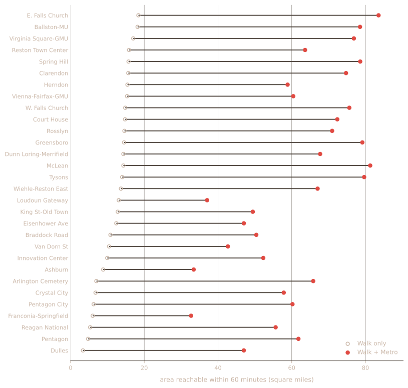
The rail times are modeled averages and do not account for train schedules.Station-to-station times come from a hand-verified line model — distance over speed, plus a dwell at each stop, with transfers free at shared stations — rather than from WMATA’s published timetable feed. Waiting time is a schedule average and there is no penalty for transferring, so a trip requiring a change is timed a little optimistically. The model checks out against published end-to-end times where those exist: Wiehle–Reston East to Rosslyn at 33 minutes, Ashburn to Pentagon at 61. Each cell takes the faster of walking the whole way or walking, riding, and walking again. Walking speed is flat, and doesn’t account for hindrances such as terrain or stoplights.